


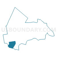
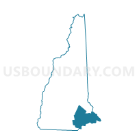
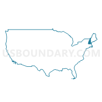
TOWN OF WINDHAM Voting District, Rockingham County, New Hampshire
About
Outline

Summary
| Unique Area Identifier | 616417 |
| Name | TOWN OF WINDHAM Voting District |
| County | Rockingham County |
| State | New Hampshire |
| Area (square miles) | 27.86 |
| Land Area (square miles) | 26.81 |
| Water Area (square miles) | 1.06 |
| % of Land Area | 96.20 |
| % of Water Area | 3.80 |
| Latitude of the Internal Point | 42.81109210 |
| Longtitude of the Internal Point | -71.30268780 |
Maps
Graphs
Select a template below for downloading or customizing gragh for TOWN OF WINDHAM Voting District, Rockingham County, New Hampshire


Neighbors
Neighoring Voting District (by Name) Neighboring Voting District on the Map
- DERRY WARD 1, Rockingham County, NH
- DERRY WARD 2, Rockingham County, NH
- TOWN OF HUDSON Voting District, Hillsborough County, NH
- TOWN OF LONDONDERRY Voting District, Rockingham County, NH
- TOWN OF PELHAM Voting District, Hillsborough County, NH
- TOWN OF SALEM Voting District, Rockingham County, NH
Top 10 Neighboring County Subdivision (by Population) Neighboring County Subdivision on the Map
- Derry town, Rockingham County, NH (33,109)
- Salem town, Rockingham County, NH (28,776)
- Hudson town, Hillsborough County, NH (24,467)
- Londonderry town, Rockingham County, NH (24,129)
- Windham town, Rockingham County, NH (13,592)
- Pelham town, Hillsborough County, NH (12,897)
Top 10 Neighboring Place (by Population) Neighboring Place on the Map
Top 10 Neighboring Elementary School District (by Population) Neighboring Elementary School District on the Map
Top 10 Neighboring Unified School District (by Population) Neighboring Unified School District on the Map
- Salem School District, NH (28,776)
- Hudson School District, NH (24,467)
- Londonderry School District, NH (24,129)
- Windham School District, NH (13,592)
- Pelham School District, NH (12,897)
Top 10 Neighboring State Legislative District Lower Chamber (by Population) Neighboring State Legislative District Lower Chamber on the Map
- State House District 27, Hillsborough County, NH (45,635)
- State House District 4, Rockingham County, NH (42,368)
- State House District 5, Rockingham County, NH (33,109)
- State House District 3, Rockingham County, NH (29,082)
Top 10 Neighboring State Legislative District Upper Chamber (by Population) Neighboring State Legislative District Upper Chamber on the Map
- State Senate District 22, NH (56,033)
- State Senate District 19, NH (55,224)
- State Senate District 14, NH (53,549)
Top 10 Neighboring 111th Congressional District (by Population) Neighboring 111th Congressional District on the Map
Top 10 Neighboring Census Tract (by Population) Neighboring Census Tract on the Map
- Census Tract 123, Hillsborough County, NH (8,930)
- Census Tract 121, Hillsborough County, NH (8,201)
- Census Tract 1061.01, Rockingham County, NH (7,264)
- Census Tract 36.01, Rockingham County, NH (6,817)
- Census Tract 1001, Rockingham County, NH (6,658)
- Census Tract 1061.02, Rockingham County, NH (6,328)
- Census Tract 36.02, Rockingham County, NH (5,593)
- Census Tract 2001, Hillsborough County, NH (4,522)
- Census Tract 1003.01, Rockingham County, NH (4,521)
- Census Tract 2002, Hillsborough County, NH (4,092)
Top 10 Neighboring 5-Digit ZIP Code Tabulation Area (by Population) Neighboring 5-Digit ZIP Code Tabulation Area on the Map
- 03038, NH (33,269)
- 03079, NH (28,776)
- 03051, NH (24,480)
- 03053, NH (23,957)
- 03087, NH (13,592)
- 03076, NH (12,897)